Plenty Highway
- Details: DS Plenty Highway
- Availability: In Stock
Description
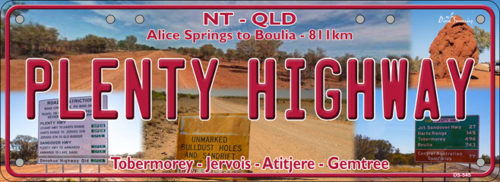
PLENTY HIGHWAY – The Plenty Highway is 811km between Boulia in QLD and Alice Springs in the NT. The purists regard the best section to drive as the 498 kms outback track (mostly unsealed) between the Stuart Highway and north-western Queensland. The road begins at a turnoff from the Stuart Highway 68 kilometres north of Alice Springs, and finishes at Tobermorey Homestead on the Northern Territory/Queensland border. It then continues for another 249 km to Boulia Queensland, as the Donohue Highway.
The first 100 kilometres from the Stuart Highway to Ongeva Creek is sealed. The remaining 178 km to Jervois Homestead is unsealed as is the rest of the track to Boulia. Information about its condition may be obtained from the Harts Range police station, 112 km from the Stuart Highway. East of Jervois Homestead, the road is formed earth, deteriorating to rocks and bulldust as it nears Tobermorey, 213 km from Jervois Homestead. The road north to Urandangi and thence to Mount Isa bears left just before Tobermorey.
As at other Northern Territory or Queensland border crossings, the road may deteriorate east of the border into Queensland with deep potholes and bulldust. It is 249 km from Tobermorey to Boulia and good camping may be found at the Georgina River, at about the 125 km mark. Fuel and food may be obtained at Gemtree, Atitjere community, Jervois Homestead and Boulia. As of June 2018, fuel and camping is available at Tobermorey. The Donohue Highway is not suitable for ordinary caravans and road trains up to 53 metres in length use both highways.