Anne Beadell Highway
- Details: DS Anne Beadell Highway
- Availability: In Stock
Description
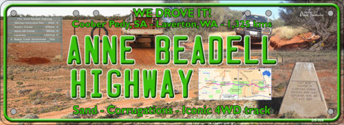
The ANNE BEADELL HIGHWAY is an outback unsealed track linking Coober Pedy, South Australia, and Laverton, Western Australia, a total distance of 1,325 km. The track was surveyed and built by Len Beadell, Australian surveyor, who named it after his wife. The track passes through remote arid deserts and scrub territory of South Australia and Western Australia, which often have summer temperatures as high as 50 degrees Celsius (122 degrees Fahrenheit). Sand dunes predominate for most of the track.
The road was constructed to provide access for a series of surveys adding to the overall geodetic survey of unexplored parts of Australia. The information was required for rocket range projects at Woomera. Construction was completed in five stages, spanning nine years from 1953 to 1962. The first stage from Mabel Creek station near Coober Pedy, west towards Emu Field, was built in February and March 1953 to provide access for British atomic tests at Emu Field. This stage preceded the formation of Beadell’s Gunbarrel Road Construction Party, and was the first road built by Beadell.
The second stage was begun in July 1957 in the reverse direction, from Anne’s Corner towards Emu Field, after Beadell had completed the Mount Davies Road in the north-west of South Australia. The third stage was commenced in August 1961, running westward from Anne’s Corner to Vokes Hill. In April 1962 the fourth stage proceeded west from Vokes Hill, beyond Serpentine Lakes towards the future Neale Junction where the construction party arrived on 16 August. From Neale Junction during August and September 1962 the north-south Connie Sue Highway was constructed between Warburton and Rawlinna. The fifth stage of the Anne Beadell Highway was then commenced, and was completed at Yamarna near Lake Yeo when it joined an existing track to Laverton on 17 November 1962.
Beadell put considerable effort into rediscovering Vokes Hill while surveying the track, as a new device called a Tellurometer was being introduced. It used radio waves for distance measurement, thus requiring high points for operation